India's Great Nicobar Megaport Sets Up a Direct Challenge to Singapore and Colombo
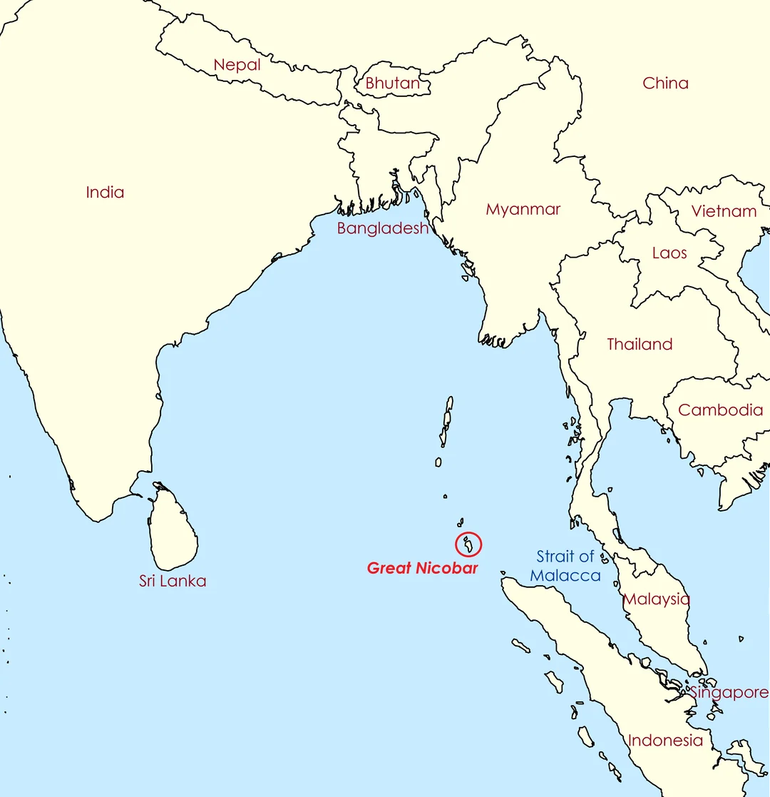
India is advancing one of its most ambitious infrastructure undertakings in decades on Great Nicobar Island, the southernmost tip of the Andaman and Nicobar archipelago. The $9 billion megaport, airport and township development sits closer to Indonesia than to mainland India and creates a strategic foothold near the Strait of Malacca, one of the world's busiest maritime corridors.
As of May 2026, construction is actively progressing. Bulldozers have begun clearing forest land at Campbell Bay and surrounding areas, with AFP coverage from March 2026 documenting active road building and tarmac works on the island. The first phase, valued at around $4 billion, includes the International Container Transhipment Port at Galathea Bay and a greenfield international airport at Campbell Bay. According to the archipelago's governor, former navy admiral Devendra Kumar Joshi, this phase is targeted for completion within three years, with operations expected to begin by 2028.
Strategic location near global shipping lanes
Great Nicobar sits roughly 40 nautical miles from the East-West international shipping route. The Strait of Malacca handles between a quarter and a third of global seaborne trade. For India, around 60 percent of sea-based trade and a significant share of liquefied natural gas imports pass through this narrow passage. The project occupies a position at the eastern entrance to the strait, giving New Delhi direct visibility over one of the most strategically sensitive waterways on the planet.
The Nicobar Islands belong to India because they were inherited from British India at independence in 1947. They were formally integrated in 1950 and declared a Union Territory in 1956. Their geographic distance from the mainland is outweighed by this legal continuity and by older ties dating back to the naval activity of the Chola and Maratha empires in the Bay of Bengal.
Reducing dependence on foreign transhipment hubs
A central benefit for India is the ability to reduce reliance on foreign transhipment hubs such as Colombo in Sri Lanka, Singapore, and Port Klang in Malaysia. India currently lacks sufficient deep-water berths to handle the largest container ships, forcing a substantial portion of cargo to be routed through these foreign ports. Galathea Bay offers natural water depths exceeding 20 metres, making it suitable for the largest vessels in the global fleet.
The International Container Transhipment Terminal is planned for an eventual capacity of around 14 to 16 million twenty-foot equivalent units (TEUs), with the first phase handling roughly 4 million TEUs from 2028. Once fully developed, governor Joshi has indicated the port could compete with Singapore and Port Klang to become a container handling hub in the Indo-Pacific region. Indian exporters could save an estimated $200 per container by avoiding routing through foreign hubs, generating substantial foreign exchange savings and capturing revenue that currently flows to overseas operators.
Strategic counterweight to China's Indian Ocean expansion
Around 95 percent of India's international trade by volume and 70 percent by value moves by sea, supported by a network of 12 major ports and roughly 200 smaller ports along the country's 7,516 kilometre coastline. The Great Nicobar project pushes India to operate more decisively as a maritime and archipelagic power.
For Beijing, the project sharpens the long-discussed Malacca dilemma. Roughly two-thirds of China's maritime commerce and 70 to 80 percent of its oil imports transit the Strait of Malacca, a chokepoint that China does not control. For more than two decades, Beijing has invested in alternative trade and pipeline corridors such as the China-Pakistan Economic Corridor and routes through Myanmar to reduce this vulnerability, while building commercial and naval facilities in Sri Lanka, Pakistan and Djibouti.
The new Indian infrastructure increases monitoring capacity over the eastern entrance to the strait. Sanjay Iyer, a former Indian army brigadier and military diplomat, has characterised the project as among India's most significant strategic decisions of recent decades. The position offers persistent presence in the eastern Indian Ocean rather than occasional visits, along with improved maritime domain awareness. If Chinese vessels sought to avoid the Malacca corridor, alternative routes through the Sunda Strait or Lombok Strait in Indonesia would add significant distance and operating costs.
Heightened relevance after the US-Iran war
The strategic value of controlling chokepoints has grown since the US-Iran war, which has disrupted shipping traffic and energy exports through the Strait of Hormuz. With one major chokepoint already under stress, the eastern equivalent at Malacca has gained additional importance for both producers and consumers of seaborne goods across Asia. Insurance premiums and routing decisions for tankers and container lines have become more sensitive to the security of alternative passages, raising the strategic dividend that India can extract from a permanent presence at the eastern entrance.
Defence and dual-use infrastructure
The project includes a dual-use civil and military airport at Campbell Bay. Runways across the archipelago are being upgraded or built to three kilometre strips capable of handling heavy-lift cargo aeroplanes. One already upgraded runway, on Car Nicobar island, was inaugurated in January 2026 by India's Chief of Defence Staff, Anil Chauhan. The broader military aspect of the project remains largely undisclosed.
These facilities will support the Andaman and Nicobar Command and provide India with sustained naval and air capabilities far closer to Southeast Asia than its mainland bases. The infrastructure improves India's ability to monitor Chinese PLA Navy movements between the western Pacific and the Indian Ocean, and shifts the calculus of any future regional stand-off.
Economic transformation and employment
The integrated township is designed to accommodate up to 650,000 residents over the long term. The development is expected to generate jobs across port operations, logistics, construction, services and tourism. For isolated island communities, modern infrastructure should improve access to healthcare and education. The project also includes a power generation facility, with planners signalling an increasing focus on renewable energy as the build-out progresses.
India's government has framed the project as a maritime and economic hub close to the East-West shipping route and central to defence and national security objectives. Conceptualised by NITI Aayog and implemented by the Andaman and Nicobar Islands Integrated Development Corporation, the development is structured across three phases stretching to 2047.
Phased timeline and full project scope
The development covers approximately 166 square kilometres. Phase I runs from 2025 to 2035 across 72.12 square kilometres, Phase II from 2036 to 2041 across 45.27 square kilometres, and Phase III from 2042 to 2047 across 48.71 square kilometres. The total area includes around 35 square kilometres of revenue land and roughly 131 square kilometres of forest land.
Environmental and social concerns
The project has attracted significant criticism over its ecological footprint. Around 130 square kilometres of forest land is being diverted, with estimates suggesting up to 852,000 trees could be felled. Galathea Bay is an important nesting site for the endangered giant leatherback turtle. More than 85 percent of Great Nicobar is designated as a biosphere reserve and forms part of UNESCO's Man and Biosphere Programme, with roughly 1,700 endemic faunal species recorded on the island.
The development also raises questions about the welfare of indigenous communities, including the Shompen hunter-gatherers and the Nicobarese, totalling around 1,200 people. Indian opposition leader Rahul Gandhi has warned that the project could damage large areas of rainforest. A government-appointed environmental panel has approved the project and India's environmental court has rejected petitions citing ecological concerns. The government insists it has met all environmental requirements and has pledged to protect local communities and unique flora and fauna through protected zones.
If delivered on schedule, the Great Nicobar megaport will reshape Indo-Pacific trade flows by offering an alternative to established transhipment hubs and by strengthening India's maritime depth in the eastern Indian Ocean. The first measurable effects on global supply chains are expected from 2028, when the initial phase of the Galathea Bay port comes online, with broader strategic and commercial impacts unfolding over the following two decades.
💡 Alternative Solution
Continued routing through foreign transhipment hubs at Colombo, Singapore and Port Klang, alternative shipping passages via the Sunda Strait and Lombok Strait in Indonesia, expanded use of Vizhinjam International Seaport on India's west coast for west-side cargo, and overland trade corridors such as the China-Pakistan Economic Corridor and Myanmar pipeline routes for cargo bypassing the Malacca Strait